Slollicum Peak in Harrison, BC

11:33 PM

First wrong turn I took was driving down the right side of the logging road after turning on the Slollicum road instead of parking behind the boulder and walking up the left. Sometimes even a wrong turn can give you a great view but, definitely was some rough terrain to drive on! 
Take Rockwell drive which will eventually become a kind of rough gravel road when you take a slight left turn at the end (I used siri and she took me to this point no problem).  Look to the right for a big road sign that says "Slollicum", turn right and then you will drive a short distance before you will come up to a fork in the road. I parked behind this boulder on the right hand fork, the path you will be traveling up is the left road. 
Follow this trail up, keep your eye out for any 4X4 or ATV's that might be driving down. As you are walking up you will actually see a mini trail going towards the left leading to probably a drinking spot as there are beer cans and a fireplace, disregard this as this is not the trail you want (see photo below for the real trail).
You will start climbing up a steeper part of the road, it will fork out and one part will just keep going straight up while on the left hand side you will see some flagging tape on a tree. Go left towards the forest.

Along the way before the forest you will see a nice memorial tree.
Right when you enter the forest, keep your eye out on the right hand side for flagging tape, it will be going up this very steep talus. It can be easy to miss (we actually walked passed it because there is pink flagging tape in the forest which will lead you to a very small waterfall/creek). Careful going up this talus, probably best to wait for one person to go up or down and then the next person since you could knock a rock down and hit the other person. 
After climbing up the talus, you will be walking across this rocky spot. One thing to watch for are these intense thorns!! They are all over this trail, sometimes they are hidden by rocks and boy do they hurt! 
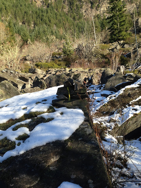
These cairns with flagging tape and the flagging tape on the branches (photos below) will lead you to where you will need to go which will curve you towards the left. You can also see some of these thorns I was talking about before.


Before walking into the forest for a short time, I climbed up a big rock to get this photo. It is such a great view that I took a lot of photos of it. 
This was another beauty we saw along the way, at least to my friend and I, the way the snow looked on the rocks looked like coconut flakes =) However, of course since these are rocks covered in ice, be careful! I kind of pushed the ice off of the rocks before I walked on them just so it would also be easy to see our path on the way back. 
You will go left after that frosted rocky part and travel on this road for maybe 10min before you are rewarded with a spectacular view of Harrison lake (below). 
You can take a break here or even just stop and have this be the end of your trail, the view is fantastic!!
If you decide to go forward, you will be traveling along this degraded logging road for a while. There will be blue flagging tape on the trees on the left hand side. On the way back we ran and it took us 15 min on this logging road, so you will be traveling on this for a while if you are walking.
Several times along the way you will come across creeks, this was the most shallow of them all but there will be others that will be steeper and deeper. Be prepared with either getting your feet wet or have some waterproof footwear, unless you are able to leap across, the rocks can be slippery and unstable so careful when using them to cross.
Eventually the logging road will come up to this junction. This is when things start getting tricky, at least for us in the wintertime. You will climb up this steep slope on the right, as you can see the orange flagging tape in the photo above.
Right away climbing up the slope, you will encounter this deep ravine, it isn't too hard to cross, we just had to hold on to any branches to avoid slipping.
Now the trail will start!
Wow we did not expect this much snow, it went past our knees and sometimes our thighs, probably speaks about our inexperience of how we wouldn't expect snow like this in late November. It became a lot more difficult in some spots to see the trail markers because they were covered in snow however, I could see there were spots where the snow was indented, as if there was a trail below it.

Eventually, after a lot of hard work (it is so much more difficult to hike in the snow), we come to a part where we climb up this rock. Again as before, I patted the snow off of the rocks before I climbed them so that on the way back I knew where to step, it's a good way to avoid some slipping.


After climbing up that rock and all that steep hiking, we thought we reached the peak and then.... we realized that we would have to climb down a big ravine and up this other mountain to where the Slollicum peak is. Sigh, since we got lost for 1.5h at the start of our journey, we couldn't risk trying to go to the peak since we knew it would be getting dark. Instead, we stopped at this ledge to take a break and eat lunch.
Looking down at what we would have to hike back after our lunch...
A cute sapling I found on the ledge we were sitting on.

This was my face of defeat, I don't like to give up but in this case we had to. I plan to make it to the top next year when there isn't so much snow (although the snow wasn't too too bad).
Even though we never made it to the actual peak, I consider this trip worth it. The views I saw along the way were still spectacular, it was peaceful eating here and it was a great endurance test!


This is mini waterfall I was talking about at the very start of when we went the wrong way since we missed turning right and climbing up the talus. So if you see this, you walked too far and the terrain here is very difficult as a lot of trees have fallen.


Tips

  • I would agree with other sites online that say to give yourself about 6h and that this hike is intermediate level, we got lost for an 1.5h near the start so we couldn't make it to the peak. We actually ran on the way back, mostly just the logging road as it was hard to run down that slippery mountain. With running, by the time we made it back to the car it was already starting to get dark, we were pretty glad we decided to run back! 
  • If you do this in the fall and winter, be prepared for some deep snow. Since it is a lot of hard work, I would say you don't need to wear intense winter gear, just dress in layers (I took my jacket off, only when we took a break at the top I put my jacket back on for a short time then took it back off). I was really glad I sported some leather gloves because there were a lot of thorn bushes and the gloves saved myself from being stabbed a lot, and I had to grab a lot of random branches and trees to avoid slipping.
  • This trail was really slippery as some parts were quite steep, I used real hiking boots this time (thank you gortex for keeping my feet dry!) However, the grip was not meant for snow so I was slipping and sliding a lot, on the way back I actually ended up using my feet like skis and slid down those steep sections so that I could get down faster. 
  • You can use siri to take you to Rockwell drive and then turning left onto a forest service road but, she will actually lead you to some random point farther away. Keep your eye out on the right for the Slollicum sign and this is where you will turn in.

0 comments