
Dewdney Grind + Dewdney Peak, BC in November
2:31 PMThis trail is intermediate (I consider myself medium fitness level and I felt super out of shape doing this trail). I would say that if you have a walking/hiking stick, it would be good to bring for some parts where it can get quite steep. I did this hike in running shoes and there were some parts where I was on my hands and knees just because the pine needles were so slippery. To get to the cabin, it only took us about an hour, we would have been faster but, we almost went the wrong way as a logging road intersects the middle of the trail but, we actually were lucky and a friendly local pointed us in the right direction.

 |
| Drive up the gravel road (Norrish Creek Forest road) and on the right hand side you will see yellow road signs, I parked near this 0km sign. On the left hand side you will find a very faint and beat up plastic bag (as seen here), this is the South trail entrance that you will go up. |
 |
| This trail has grind in its name for a reason. You will find red markers on the trees to follow up. |

 |
| Down view of what I have hiked so far. |
 | ||
Coming out of the forest from the South trail, almost got lost because we started going down the logging road when really we should be looking towards this big pile of logs that were lying along the road. There will be a very narrow opening amongst the logs and it will look like a trail going up, once you pass the logs the trail will be more obvious leading to the cabin. Even this blue paint on the trees is a way that some people have used to mark the trails.
|

 |
| Going up towards the cabin, the markers should be popping up again. This forest is very thick so from the outside you wouldn't be able to see this trail, again need to keep a careful eye amongst some logs for an opening and something that looks like a previously walked trail. |
 |
| View from the cabin. |
 |
| This cabin is really spectacular, it was built by the people. They have a book inside for people to sign which the owner of this cabin told us they are already on their 7th or 8th book with people from all over the World signing it. |
 |
| To the right of the view from the cabin by a fire pit, you will see another trail, it is only about 50m and it leads to this picnic table. A gorgeous spot for a meal. |
 |
| Inside of the cabin, a memorial photo stating how this cabin was built in honour of a fallen firefighter. |
 |
| Continuing now to the peak of Dewdney mountain, you can see a red tag to the left. If you want to go to the peak, we were told to walk around to the left of the outhouse at the back of the cabin and then you should find a trail. |

 |
| You end up reaching a point where you will leave the forest and walk over this logging road and look towards the forest above you for tags or trail. I actually recommend taking flagging tape or taking photos or using something to remember where you came out of the forest from if you go to the peak. On the way back from the peak it can be tricky to remember where came from. |
 |
| Unlike the Grouse Grind, there are no stairs to make this trek slightly easier. |
 |
| On the way to the peak you will come across this section where all the trees are chopped down, there used to be a bridge to go across this creek (pictured below) but, it is knocked down. You can walk around this mess to the left though, be aware to start looking far ahead and around since now some of these fallen trees used to be the ones with tags on them (you will probably find tags on the ground or on the tree that is on the ground). I was able to see the tags far ahead, the tags also will be white/silver. |
 |
| crossing the creek. |

 |
| As you go up the peak, now it will start feeling colder and there will be some snow. There is a lot of going up up up then down down down. |


 |
| This point here is not the peak, we had no service till about here when we realized that we passed the peak. The peak doesn't feel very obvious and the whole time you are in the forest. We decided to stop here for lunch before rushing to head back before the sun went down. It was freezing cold!! |
 |
| I read online about how past the peak there is a "lookout" and even the white/silver tags will lead you to this point and then you can't see them anymore (beyond that forest is just the other part of this logging road curved around). I walked and explored this area and I didn't find any lookout :/ it was pretty disappointing, I am guessing there used to be one but, the logging road changed what or where it was (possibly the tags are missing). |
 |
On the way back we decided to take the North trail, this is where I wish we took some flagging tape with us to notify us where we popped out from the forest from the logging roads. Then it took some cell phone service searching and detective work to locate where the North trail opening was. You just have to look down towards the forest and look out for cairns (rocks that have been built up/place by humans), flagging tape, blue paint. In this photo you can see there is orange flagging tape on these trees, sometimes the flagging tape is yellow or pink, it isn't always going to be one colour. |
 |
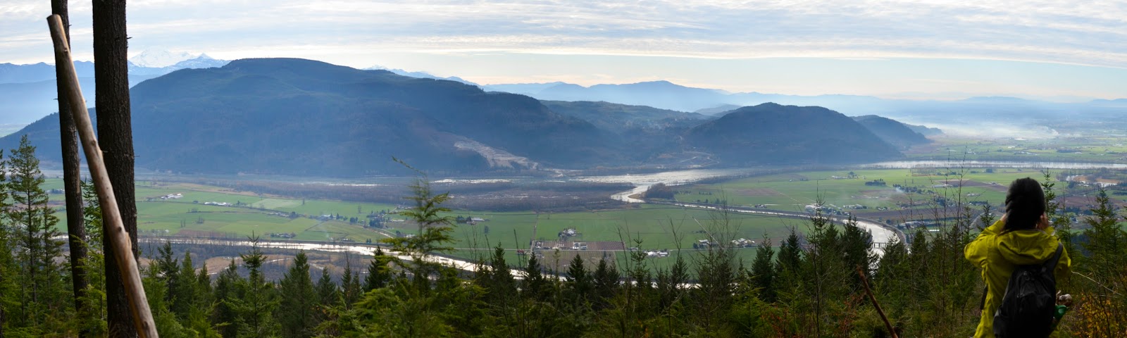
| This view was spectacular! It was worth all the hassle of going down the North trail instead of the South, from here we are going to be going down towards a logging road, by this point the flagging tape or markers are more regular and a tad easier to spot. |
 |
| These are some cairns to look out for on the North trail. |
 |
| At the end of the North trail, it actually splits in two, take the trail to the right. The one straight ahead is overgrown, both will take you to this road here but, the overgrown one will take longer and plus you have to watch out for a lot of thorns. |
Tips
- If you have never done this before and aren't going with someone that has done it, I think some flagging tape to mark off the exits from the forest so that you remember your way back would be useful. More if you go to the peak since you will have traveled away from the site for a while and it can be hard to remember where you came from.
- The markers won't always be up on the tree, some of them have fallen due to logging. The markers on the South trail going up will be red, past the cabin and going to the peak will change to white/silver. Going back and looking for the North trail, the markers will vary to being cairns/rocks stacked up (photo above), flagging tape and the entrance/exits from the logging road might even have stumps that have blue paint on them. I used a very careful eye sometimes and looked for anything that looked like a walked trail and then looked around the trees there for any sort of markers to follow. The North trail at the start from the cabin, is a lot trickier in that manner.
- If on the way back you can't remember the trail back or can't find the North trail, you can take the logging road back to the bottom where you parked your car. Just know if you parked by the entrance of the South trail, that you will have to walk down the gravel forest road down a bit to get back to your car.
- I would also say that going to the peak, as of this point in November 2015, it isn't really worth it besides just for exercise purposes as the logging makes it difficult to get around and there isn't a view (at least I never found one). The hike to the cabin is definitely worth it though! Intense and the view from the cabin is worth it and going down the North trail has another spectacular view also.
- Also if you already have a walking stick, it is pretty useful to use on this trail to keep your balance. I picked up a stick along the trail and was very grateful to use it on the way back, kept me from falling many times! I did this trail in running shoes, my friend had trail runners, I only had issues on a couple of steep parts covered in pine needles as it was slippery.
- Going to the peak and back, along with time spent being lost, it took us a little less than 6h.


0 comments